![]()
19 South Main St.
West side of street
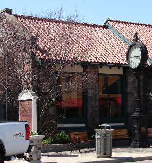
The building which stands on this site now was built in 1928/29 as an addition to the original Clarkston State Bank structure.
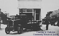
This property was a part of the "Mill property" to the west until 1849 when the tax records listed Nelson W. Clark and Abraham Houghtelin, (partners in the "Mill" property for a time), for Lots 2 & 3 Block 25, assessed value $1900. The 1872 map of the Village shows the footprint of a building on this site, at the time, with the designation R. Brockenshaw. Brockenshaw & Richardson were listed as manufacturers of boots and shoes. (There was no property listed in the tax rolls under either name for this piece. Perhaps they rented.) There were several owners between 1891 & 1911 when Leman Gulick was listed for the north 15' of Lot 2 Block 25, assessed value $250. A glimpse of the single story wooden false-front building on this site can be seen in a circa 1913 photo (page 54, Heritage). By 1914 Jake Gulick had a barbershop here (see interior photo, Heritage, pg.51). Jake moved to Davisburg after he sold the property to Harvey DeMond/DeMund about 1920. "Dude" DeMond's barbershop and his wife's beauty shop occupied the building until 1925. A Clarkston News item, 8/30/35, noted "Rita Chisholm will take over the Demond Beauty Shop, 19 S. Main". A December 6 item of the same year said Kennedy's Barbershop & Mrs. Chisholm's Beauty Shop "will move across the street". (18 S. Main.) The wooden building was later moved off the lot, see photo below. Burt Lewis became the owner of the lot in 1926/27. The lot was then sold to the bank. A stone addition which matched the original bank building was constructed in 1928/29. In 1937 The King Insurance Agency had its office in the Bank building for a time. They moved to the brick building at 23 S. Main by 1966.
Official Property Description:
- The north 12' of Lot 2 Block 25 of Nelson W. Clark's Original Plat of the Village in the Southwest 1/4 of Secton 20 in Independence Township.
- Lot 78 of the Assessor's Plat.
Significant Property History:
- 1849 Nelson W. Clark & Abraham Houghtelin, Lots 2 & 3 Block 25, "last description Known as Mill property", assessed valuie $1900.
- 1850 Nelson W. Clark, Lots 1, 2, and 3 of Block 25, assessed value $500.
- 1857 E. Hirst, Lots 2 and 3 of Block 25.
- 1858 E. Hirst, Lot 1 and 15' off the north side of Lot 2 Block 25, "occupied together as a store".
- 1860 E. Hirst, Lot 2 and 3, "exc.15' off the side, including the house which belongs to the mill".
- 1877 Erastus Stiff, Lot 2 and 3 Block 25, "except 15' off the north side which is Dressers, & 67' on Main, running back to the Foundry property", assessed value $250.
- 1881 Theodocia Stiff, the undivided half of the property, north by Hammond, J.H. Dresser and Bartlett, west by Mrs. West, south by M. A. Root, east by Main, assessed value $300.
- 1884 Mrs. H. T. Hirst, north by E. Goodenough, south by M. A. Root, assessed value $300. E. D. Goodenough, 15' off the south side of Lot 1 Block 25, assessed value $200.
- 1891 Herman Wormer/Werner, Lot 2 and west 1\2 Lot 5 Block 2, assessed value $100. (this is corrected by 1903 when the Block no. becomes 25.)
- 1894 Herman Wormer/Werner, assessed value $200. Geo. Alexander, assessed value $200
- 1902 Albert Osmun, assessed value $200.
- 1903 Mrs. Lena Bellarby, Lot 2 , the north 1/2 of Lot 5 (must mean Lot 3) Block 25, assessed value $300.
- 1907 Mrs. Lena Bellarby.
- 1909 Tax records are very confused.
- 1910 Clarence Drake, assessed value $250.
- 1911 Leman Gulick, the north 15' of Lot 2 Block 25, assessed value $250.
- 1914 Jake Gulick, assessed value $300, see page 51, Heritage.
- 1917 Jake Gulick.
- 1920 Harvey Demund, assessed value $500.
- 1925 Harvey Demund, assessed value $600.
- 1926 Bert Lewis, assessed value $700.
- 1927 Bert Lewis, assessed value $700.